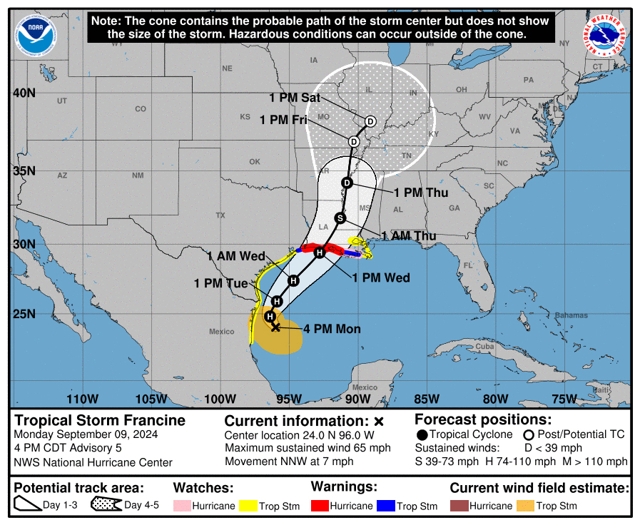
The tropical disturbance brewing in the Gulf of Mexico has formed into Tropical Storm Francine as it tracks toward the Louisiana coast, according to the National Hurricane Center. As of Monday afternoon, the storm is expected to go east of Houston with minimal impact to the city and some impact to Galveston.
According to the 4 p.m. advisory from the National Hurricane Center, the storm is expected to intensify and land on Wednesday as a Cat. 2 hurricane somewhere along the Louisiana coast.
“Most of the forecasting has gradually shifted a little further east,” said Matt Lanza, meteorologist and editor for Space City Weather. “For Houston overall, just being honest here, the impacts to the city do not look significant at all at this point. It’s probably going to come in somewhere near Vermillion Bay in Central Louisiana.”
With a storm track so far offshore, there will be some storm surge with minor tidal flooding and storm gusts in Galveston and maybe in Galveston Bay, Lanza said. There will be no wind of any consequence in Houston or the suburbs as of now.
Experts predict that Galveston will see some rainfall, especially Tuesday ahead of the storm. There will be clouds and a chance of showers on Tuesday and Wednesday in Houston, but Lanza said that should be manageable. No serious flooding is expected.
Harris County Judge Lina Hidalgo acknowledged in a statement that many residents “are worried about Tropical Storm Francine, especially with some of us still recovering from the effects of Hurricane Beryl.”
Hidalgo said that the county’s Office of Emergency Management has been activated and is monitoring the situation but, “we feel confident that the likelihood of the tropical storm hitting Harris County is very low. Of course, the possibility exists that there could be a change, but it’s unlikely.”
The Houston Independent School District said in a statement that it’s monitoring the developing tropical system but that “At this time there are no planned changes to district operations or school schedules.”
HISD indicated that they’ll “notify families and staff should the situation change.” Similar statements were issued by Alief ISD and Spring ISD.
In preparation for the storm, Galveston County said it’s watching for any serious impacts.
“The Galveston Office of Emergency Management has upped our activation level and we’re monitoring the situation as it moves through the Gulf of Mexico,” said Spencer Lewis, communications director for Galveston County. “We’re well-prepared and equipped to handle anything that comes our way.”
The Harris County Flood Control District will be meeting at TranStar with the Harris County Office of Emergency Management on Monday to complete the standard preparation before a storm.
“We have been following the storm quite closely and fortunately for us, it looks like it’s tracking to Louisiana,” said Emily Woodell, chief external affairs officer with the Harris County Flood Control District. “We are making sure our system is ready in case a last-minute direction change does occur.”
The impacts to Houston could increase if the tropical storm struggles to develop or weakens, according to Lanza. The stronger the storm is, the further east the storm will end up. Still, experts say that the impact would be nothing even close to Hurricane Beryl.
“Most people should be fine, but I’ll still encourage everyone to be prepared just in case,” Lanza said.
Reporter Hanna Holthaus contributed to this report.

